Solitude: 9/10
Beauty: 10/10
Water: In the section of Buckskin Gulch, there is none. The other two sections had plenty of seeps and springs. We also used the PNG water purification chemicals as opposed to alum to clean up the silty water of the Pariah.
Navigation: Simply follow the river downstream. However, I was under the impression that I would not get any GPS signal as the canyon is very narrow. This is only the case in the Buckskin section. I did have a good GPS/Iridium signal after we got out of Buckskin Gulch.
Distance: It’s reported to be 43 miles. I would judge it to be more because that seems to be a line drawn right down the center of the canyon. And you’re moving laterally a large percentage of the time.
Route: https://caltopo.com/m/5TFM
Video: The target audience is my elderly mother: https://youtu.be/_efw4toVVEs?si=biupPDDCsVfHNP_f
There’s a lot of information out there already for hiking Buckskin Gulch and Pariah Canyon. I just figured I’d add a few things that weren’t clear to me during our investigation of the trail before we went.
Obtaining the permit, while difficult, is not impossible if you plan ahead. We flew into Las Vegas and immediately drove to Lee’s Ferry, Arizona, with a quick stop in St. George, Utah, to validate our permit. The people in the office were extremely friendly and helpful.
We hiked from Wire Pass to Lee’s Ferry in four full days, spending three nights.
We parked our car in Lee’s Ferry, which is in Arizona, so we were off by an hour to meet a shuttle driver back to Wire Pass. The whole Arizona daylight savings time thing is really confusing when you fly into Las Vegas, drive through Utah, and end up in Arizona. On the night before we started the hike, we pitched our tent in the dirt parking lot at the Lee’s Ferry campground. This was midweek, and we were at the far end of the parking lot, so we were 250 yards from others.
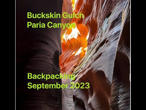
The hike can be broadly segmented into three sections: Buckskin Gulch, the upper Pariah Canyon, and the lower end of the Pariah Canyon.
Buckskin Gulch is extremely narrow. There’s absolutely no place to stop in between. I noticed a few ledges where one could perhaps spend the night if necessary, but it’s best to traverse the full 13 or 14 miles in one go. The path is slow and can be very muddy, even on a dry day. I won’t dwell on the numerous reports, but it’s reckless to venture in if there’s a risk of rain and potential flash floods. The first campground is situated high up on the left-hand side, about 500 yards from the confluence of the Pariah River and Buckskin Gulch.
Once you leave Buckskin Gulch and venture into Pariah Canyon, you’ll find plenty of sandy banks on either side of the river. While there’s no distinct trail, you’ll be following the river downstream. It’s not worth trying to hop from rock to rock, as you’ll end up crossing the river dozens of times.
In the final stretch of the hike, you’ll navigate up and over shoals, continuing to follow the river down to Lee’s Ferry. This is the only section of the trail where you will be traveling at your normal pace. Everything else takes more time than usual.
This trail is perhaps the most beautiful I’ve ever hiked.


Home › Forums › Buckskin Gulch / Paria Canyon: Utah