What is this trip report really about? Why post it? We ran into an unexpected challenge. River crossings. I know, many of you readers will have crossed many rivers, some fast, some gentle, that are knee deep or thigh deep or hip deep, and wide. One of us on this trip had a bit of such experience, but for the other two, it was totally new, and seriously daunting. We learned a lot. So if rivers are no big deal to you, please be patient with us. Our friend was.
Destination: Yellowstone National Park, Lone Star to Grassy Lake through Bechler River corridor.
Cast of characters: Me (age 72), my sister (age 69), and our friend K, (63). My husband R and my brother-in-law H were also on the trip but they don’t backpack anymore. We all live in Texas. R caught a cold and flew home early. Planning: I made most of the advance plans like figuring out a route and getting the permit, because I have wanted to try some backcountry in Yellowstone for a long time. I talked to a friend I worked with at REI, who also guides for REI Adventures in Yellowstone. He said the Bechler river crossings are wet but “not too bad.” Made sense to me, since they take guided trips through there. Mileages between camps were determined by what sites I could get on the permit.
Logistics: C, H, and I arrived at Grant Village on 8/29. We sorted gear and provisions. On Wednesday 8/30 C and I took C’s truck and my car down to Flagg Ranch, picked up K who had flown into Jackson Airport and caught a ride to Flagg, and then we drove to Grassy Lake Trailhead on the Ashton-Flagg Road, where we left my car, and took the truck back to Grant Village.
The following is an edited version of my real-time trip journal.
8/31 Thursday evening. Camp OA2 Firehole. Supermoon last night at Grant Village was very very bright. We were up at 7:00. Cold! Airstream thermometer 31 degrees outside. H drove us about 30 minutes to the Lone Star Trailhead. So many tourists at the parking and viewpoint. Buses-full. All the people seemed to be having a good time.
About 10:00 a.m. Bright, sunny, chilly. Hoping we didn’t forget stuff. The trail goes south through the woods. We saw birds on the ground. Squirrels. A group of day hikers returning. Along the Firehole River, smooth and clear. Occasional puffs of steam in the woods. 2.5 miles to Lone Star Geyser. An older couple from Hawaii there. The woods opened into a big clearing of white steam-baked ground around a big dome of geyser residue. The people said it would start erupting about 11:30 and then erupt big about 12:15. We decided to wait. Chilly enough for jackets. Windy. The people from HI are traveling all around in retirement. Some cyclists there too. We snacked and visited and waited. Geyser started spurting about 11:20. Then just before 12 it shot up really high for a few minutes. We all thought that was it. HI people started back, bike people left, we three wandered over to the River nearby to admire it. At 12:15 suddenly a roar! We looked back and the geyser was erupting twice as high! We (and the HI couple who had also noticed because they stopped in the woods to pee) all returned and admired this 20-minute big eruption.
After that entertainment we walked on, over a footbridge across the Firehole River, past camp OA1, where a big camp was set up, probably the Americorps group from the vans at the end of the pavement. After the geyser it was forest path. Our site is about 3/4 mile farther. Quiet, open forest, with a big thermal field just before camp. We lunched again, had a time getting our cords over the bar for our food bags. Throwing that high is hard to aim, for us folks who don’t practice throwing. Took a rest in our tents, visited the river; C & I walked around the steaming pools and rivulets, all different colors. An old dollar bill in one. Farther into the forest, a bunch of holes hidden in the ground here and there, not full of water but pumping out hot air. And some pools actually boiling! Later after another layabout, and a walk for C and K around the thermal field again, we took our food bags down, made supper, and restrung the bags. Now there are some birds squawking. The sun is behind the ridge. So peaceful.
9/1 Friday evening. Camp 9B9 Albright Falls. This morning up about 7:15. Cold. Moon still especially bright; it washed out the stars. Sleep fitful. Pretty morning, very sunny. Today was our longest planned hiking day. My guess about 12+ miles. We got out of camp at 9:20. C packed up our tent. (I am not used to anyone else taking responsibility for this.) We set forth to climb the Divide. Mostly pretty forest. Some of those wide meadows. One with a bison in the distance. Passed two guys coming back north from a backpack to Shoshone Lake. And a threesome, one young woman and two women our age. They said they had started at Bechler Ranger Station. Later I thought I should have asked them about the river crossings. Obviously they got through.
It was a climb to the Divide/saddle after we passed the Shoshone junction. We left the Firehole River. The saddle was wide, with ups and downs. Somewhere on the top we lunched, about 1:30-2:00. Open forest, flowers—mostly some kind of yellow buckwheat, purple asters, some paintbrush, yarrow, Indian pipes. Big mushrooms. Bright blue birds, very large. Squirrels. The sky clouded up around midday, stayed cloudy all afternoon. Beautiful expanse of meadows with some steam vents in the distance. One meadow was swampy for a couple hundred yards. Wet feet and socks for sure. Another had a long boardwalk, probably because of thermal hazards. A couple, on horses, with 2 additional horses carrying large bundles of gear, passed going north. They said they’d just been out for the night. With so much gear!
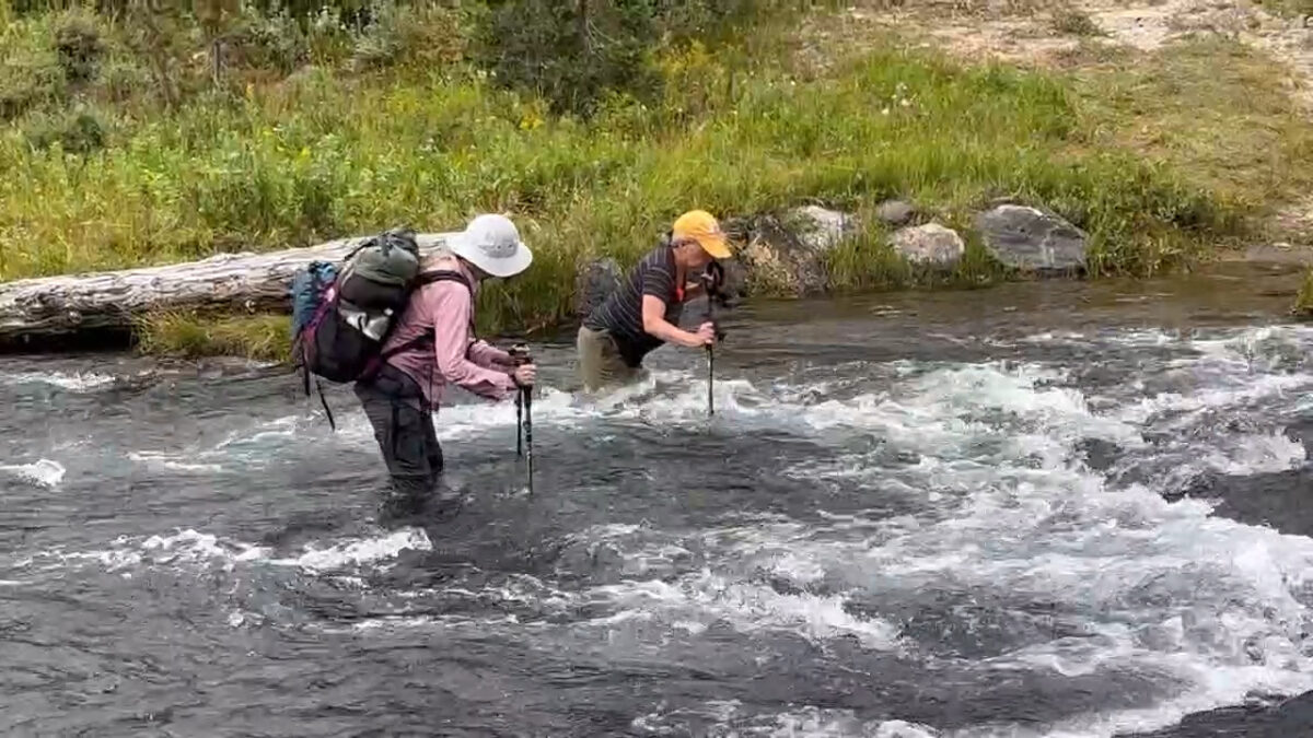
Eventually we were walking between two rivers, Gregg Fork on our right and Ferris Creek on our left, approaching Three Rivers Junction. Above the confluence, the trail crossed Ferris Creek. Which was huge. Wide and fast. After searching upstream and down, we didn’t find anything better than where the trail crossed. A tall waterfall about 1/4 mile upstream, and the confluence making the river even bigger and rougher just below the trail crossing. So we faced having to cross it as it was. I stripped to underwear on the bottom, shoes and socks on, and took a stab at it. With little experience at this sort of thing, I was taken by surprise and the force of water bowled me over. We looked for alternatives some more, and started to think about/discuss camping illegally on the near side to see if it might be lower in the morning.
K wanted to give it one more try. My problem on my first try was, I had trouble keeping upright while seeking out the next foot placement. K is stronger and has more experience with river crossings. She was steadier, and worked her way slowly across. She dropped her pack and came back across to help us. Me first. She showed me how to move down a little where the current in a couple of rough channels had slightly less force, and how to face directly upstream to maintain balance while moving sideways. K asked if she could take my pack but I explained that the pack wasn’t my problem. I hardly noticed it was there on my back. There were two tongues of faster water that were hardest to stand up in, rising to my upper thighs. I almost lost footing a few times with many rocks and holes on the bottom I could only feel for under the foaming water. I couldn’t step on a rock without slipping off and losing my balance, so had to feel for the gravel between the rocks before putting weight on my leading foot with each step. All while fighting the weight of the surging water. And slowly I made it across. Total focus, then suddenly there I was on the far shore! K headed back to help C. I made a video of those two doing the same maneuver. Now we feel very brave. And wet.
All this probably took an hour. From there, it was only about another mile to camp. Hiking along a hillside overlooking wide steaming meadows. A log ranger patrol cabin on the other side of the valley, with some horses at pasture nearby. There were hot springs spread out all across the bottomland between the trail and the river. Bright orange and yellow steaming rivulets and pools. Otherworldly thick microbial mats peeling up from the bottoms of the pools. Not the sort of hot springs to soak in! Then up the hill to the left, the side trail about 1/3 mile to our camp. Above, a gorgeous waterfall cascading down a high cliff. Just at the end of supper, thunder! Quickly a cold downpour. We rushed to don rainwear, get our food and pots hung, and hole up in our tents. Now about 8:45, I’m all stiff from sitting up writing. [Later note, for folks wondering “But what about Mr. Bubbles?” We didn’t know it was there until later after the trip. Just means we’ll need to go up there again.]
9/2 Saturday evening. Camp 9B2 Bechler Ford. Long day. Not in mileage, only about 7 miles. But definitely eventful. C and I were up about 7:30. No sign of K yet. We breakfasted. Morning chilly and clouded. Rained some more during the night but one time when I went out, moon and stars! After a while C and I broke camp. K appeared after 9:00. Turned out she was listening to a podcast in her tent and didn’t know we were up.
While we were hanging out for her to get her breakfast, a crew of park seasonals came by, inspecting and maintaining campsites. They were moving logs around to clarify paths, surveying plants, scattering native grass seed, making repairs. The leader told us the two river crossings ahead would be pretty big. Not so strong as the one yesterday, but wider and deeper. So we worried. Got some photos of the huge waterfall above camp. Also a photo of a pond below the entry path full of some kind of feathery seagrass. I asked the park crew leader where all that waterfall water was coming from, since the drainage on the map is very short, and so late in the season there wouldn’t be any snow left up on the plateau above. He thought it was just a whole lot of water that soaked in up above from the heavy snow cover last winter, that takes a while to work its way through the land.
Morning hike in pretty forest. Entering the Bechler Canyon. The two large river crossings came in the first 2-1/2 miles of our morning. First one—maybe 3 times as wide as yesterday, thigh deep, but not channeled with such force. We each waded in turn, K first of course. Still hard to stand and move feet across—hard to get a footing, feeling around for a spot in the gravel not on a slippery rock, with the leading foot, and at the same time not fall down. Then trail through forest beneath the high canyon cliffs. Second crossing a mile and a half or so later. Wider still. And deeper. More tributaries added. Hip deep. Got the bottom of my pack wet. I found if I stuck the lead trekking pole behind me while I faced upstream, it helped brace me from being pushed over by the water. A loooong way across but by that crossing we had a little more confidence. Last big crossing! [Not really, see 9/4.] We dried off (except shoes and socks, wet for the rest of the day), sat down for some lunch (for me, my leftover eggs) a ways farther through the forest.
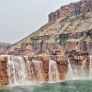
Afternoon clouding up, getting chilly. Where was that sun the camp survey ranger predicted? Alongside the wide river, cascades, river dropping down the canyon fast. Then Iris Falls, right in the river, not on a cliffside tributary as I had expected. Huge! Farther down, Colonnade Falls, two high wide falls one after the other, massive, between basalt cliffs—thus the “colonnade” name. We took a little marked side path down the hillside to a viewpoint with both falls in succession could be seen together. Well worth the side hike down the cliffside and back up. We almost skipped the side path. Glad we didn’t. For the next nearly two miles we hiked above this beautiful river through the canyon. A large—about 1/2 mile—talus mountainside to our left, full of animal holes. We imagined dens and critter highways and labyrinths under all those rocks. Took a break in a rare bit of shade there. Sun was finally out for the rest of the afternoon.
After the canyon the landscape opened to a wide meadow. The trail left the river to hug the eastern hillside for the last mile and a half to camp. The waypoint I made on the Gaia map was misplaced, and at one moment we thought we’d need to ford the main river to camp, but fortunately not; the stock camp is across but the hiker camp is on the near side. Gorgeous meadow, cattails, forbs and grasses turning yellow and red with fall on the way, dry lacy seedheads, purple asters, some berries—thimbleberries and raspberries. We had passed some of these berries earlier in the afternoon. Not enough left at the end of this dry season to attract bears anymore. Camp is in the woods near the river so we can now hear the frogs starting up as dusk falls.
After we set up camp and spent a bunch of time and humor trying to throw our bear ropes over the very high bar and missing mostly, I dozed for a bit in the open tent and then spent the rest of the hour starting on today’s notes. When I got up around 6:00 pm C and K were having after-supper tea. K took a short refreshing dip in the river earlier. My feet felt much better walking around without shoes and socks which were of course still all soaked. We watched the late afternoon light across the meadows and river. C returned to the tent to find her Nemo pad flat. Oh no! She actually managed to find the hole by dunking her pad in the river. That almost never works for me. Usually I need a soapy sponge. Then up to the tent, all dripping, desperately holding onto the spot on the muddy pad, drying it enough to mark with a pen. Then the patch, with a bit of my duck tape over it to secure. Pad is holding. Whew! Many mosquitoes here. I’m heading into the tent now to avoid. It’s 8:25.
9/3 Sunday evening. Camp 9U4 Union Falls. Oof! Rain, rain. Bright moon last night. Later towards morning a sprinkle. At breakfast it was not raining. Cloudy and chilly. We were on the trail at 8:45. Back to the main trail junction. Then the Bechler River Trail left the river, which stayed in the swampy valley. We traced the hillside southwards for 3 miles, to the Mountain Ash Trail junction. Pine forest, a few meadow clearings. Started sprinkling. We thought it might pass. Occasionally the sun peeked out. But it was not to be. Before the MAT junction, more rain, we put on our rain jackets, then off we marched across the hillside. A few ups and downs, from creek to creek.
Light rain, steady, not hard rain. Feet soaked. Leggings soaked. A couple of water breaks, brief. Getting cold. We needed to just keep moving. Passed a flagged post right in the middle of the trail, in a meadow. Kinda funny, each of us thought, but none stopped to share thoughts. Stepped over a log too, and followed the obvious trail ahead. Within a 1/4 mile, straight into a beaver swamp. Tall grass and water everywhere. A small standing stump obviously gnawed down to a point. The beginnings of a dam across a creek. And a big shallow pond. We tried to find a way through to anything that might be a trail. Mystified, we remembered the odd flag and the log. And saw a detour line on the Gaia map. Oh. Went back to the flag and sure enough, a flagged detour into the woods on the right. About halfway around, that stream came through and clearly the beavers were working that area too. The beginnings of a dam, many channels, and we still had to wade. Tried to cross the main pond, thigh deep, but no clear way up the other bank. Went around the side and found a crossing below the dam. Temporary flags again led us on, to rejoin the main trail. An adventure, and now we were even wetter, but felt privileged to see the work of the beavers up close.
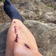
On through the cold rain. My hands were getting so cold as to stop working. Dug out gloves and rain mitts. (Add reminder to stow gloves in a more accessible, though still dry, place.) C had to help me undo the tiny snap buckles on the gloves and mitts. Clad, my hands felt so much better. We had to hike hard to stay warm. We didn’t stop for lunch. On a deep creek crossing, not too wide, K tried a log and slipped onto a neighboring lower log and got a dunking. I went to try that lower log and in stepping onto it slipped straight into hip deep water, and then just gave up and waded across through a bunch of mud and branches. C observed, and decided to wade the creek at the trail crossing. Fortunately my phone wasn’t lost or wet.
We had to check the phone map again where the Falls River Trail came in from the right. Four other hikers were coming up that trail just before we arrived. No real junction we could see, just a creek in a meadow, a hewn log placed to cross it, and trail-less ground 100 ft to the other trail. Open forest interspersed with shrubby meadows. Plants turning yellow, orange, red, brown. Purple asters still out, but fading. Brown seedheads, ready for fall.
Later at the Mountain Ash Creek crossing, we caught up with those other four hikers. Mountain Ash Creek was wide and sort of fast but “only” knee deep. One of the other hikers found a route across with not too many rocks or holes, and we followed that. The sun came out briefly right after the crossing, and I was able to take off the gloves and mitts. Then uphill and down and across for a couple more miles. The trail was ankle deep in water for much of the way, following MA Creek upstream. Junction, Union Falls Trail, half a mile, camp! Because we just kept going as fast as we could, to keep warm, we arrived about 2:00. The sun appeared while we set up camp. Felt so good! Tents, clothesline, hung wet clothes and gear on the line in the sun, and on trees. Ate supper for lunch. Hung bear lines, fiddled with knots, got the food bags strung up.
We had wanted to take a hike up to Union Falls, which would have been about an hour and a half round trip. But clouds and thunder returned. We quick-like got partially dry things back under cover, and burrowed into sleeping bags about 4:00 when heavy rain started back up. Dozed, napped, awoke at nearly 6:00, rain stopped, but too late for the hike before dark. Supper was crackers and pb and banana chips. Feeling better. Food bags hung up again just in time to dive back into tents as rain resumed. C had filled the water bags at the river at the end of supper so that was covered.
Hard rain for quite a while. Water accumulating. I had tried to scope out a tent spot where water wouldn’t collect—sometimes tricky in designated camps. A challenge to keep everything dry enough. I stuck my wet shoes, the bear spray, and a full platy under the lip of the bathtub floor to prevent accumulating water from seeping over the threshold. (The bathtub floor is held up, in the door area, by the zipped-up mesh wall, but when the zipper is open for going out and in, the floor rim drops flat.) We got some backsplash under the edge of the fly, at the tent ends. But not too bad. I wrote for a while, then needed to stretch out because my back was tired from sitting upright. Now it’s about 8:45. I am worried about tomorrow’s crossing—what if all this rain has made the Fall River too high? And will Ashton Road be passable for my little car? Nothing to be done about any of that now. Just try to get a good night’s sleep.
9/4 Monday. This is actually being composed a month later of course, since Monday was our last hiking day and after that I got all distracted by matters other than journaling. We were hoping the weather might clear some after so much rain during the night, but no luck on that. We put on our damp clothes, packed up wet tents, breakfasted as usual, and headed back for the Mountain Ash Trail junction. We knew from the map there would be a long steady climb up to a plateau and then across to the Fall River drainage. Actually hiking uphill helped keep us warm. C needed gloves for stiff hands that morning, like I did the day before. The rain kept up, light but steady. At least with the trail now ascending, the water flowed off and we weren’t ankle deep in it so much. That mountainside has a lot of interesting rock formations, like pale pillows stretching uphill and down. Volcanic? Pictures didn’t do it justice. We had about 6 miles from camp to the Grassy Lake Trailhead. I was thinking what with the weather perhaps it was just as well we only went for four nights instead of the original idea of six, and didn’t go up on the Pitchstone Plateau. Still, I’d like to go up there someday.
Somewhere beyond the top, late that morning, we passed a group of six or seven young folks on their way up. We didn’t ask where they were headed but since they didn’t have overnight kits we figured maybe Union Falls and back, although that would be a pretty long day. One of them had clearly forgotten rain gear and was all decked out in black plastic trash bags and duck tape. Which didn’t seem to be working very well for him. We visited for a moment, and asked about the condition of the Fall River crossing and the gravel road out. They said the river was wide and moving but “only” thigh deep. Although, mostly they were taller than us. And that while the road had a lot of water, there wasn’t anyplace that you couldn’t keep at least two tires on the gravel. Good news! After we dropped off the upland, the river crossing appeared sooner than I expected. We were almost done. If we had encountered this river at the beginning of our trip, I’m not sure we would have thought it passable, but after our experiences we took it in stride. Getting kind of proud of ourselves. Then only a little way to where we parked. Driving my little car out was nerve-wracking but the guy was right it was possible to negotiate the flooded parts without going all the way into the water.
Back along the gravel road, then through the park around to Old Faithful, and our expensive dinner and night at the historic inn, an experience in itself. H was right there with the Airstream in the back parking lot. The cabin was right near the one C and H stayed in almost 40 years ago when S was little, so that was memory lane for them. K and I stayed at in the historic inn room which was pretty interesting. As is the entire structure, all woodwork and old carvings. The rain had let up but the chilly cloudy weather persisted, and we had to open our window overnight because the heater was not adjustable. The dinner was sumptuous, the OF geyser was its usual spectacle. A violinist played for the evening on the mezzanine. We just relaxed.


Home › Forums › River Crossing (ahem) for the Uninitiate….